THURSDAY 6pm UPDATE: Latest information regarding Tropical Cyclone Oma is now available here.
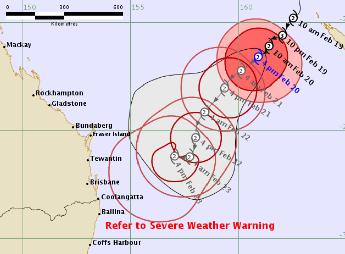
THURSDAY 11am UPDATE: Potential impact from Tropical Cyclone Oma could occur anywhere between Bundaberg and Ballina, according to latest modelling from the weather bureau.
The forecast path shown above is the bureau's best estimate of the cyclone's future movement and intensity.
“There is always some uncertainty associated with tropical cyclone forecasting and the grey zone indicates the range of likely tracks of the cyclone centre,” the bureau says.
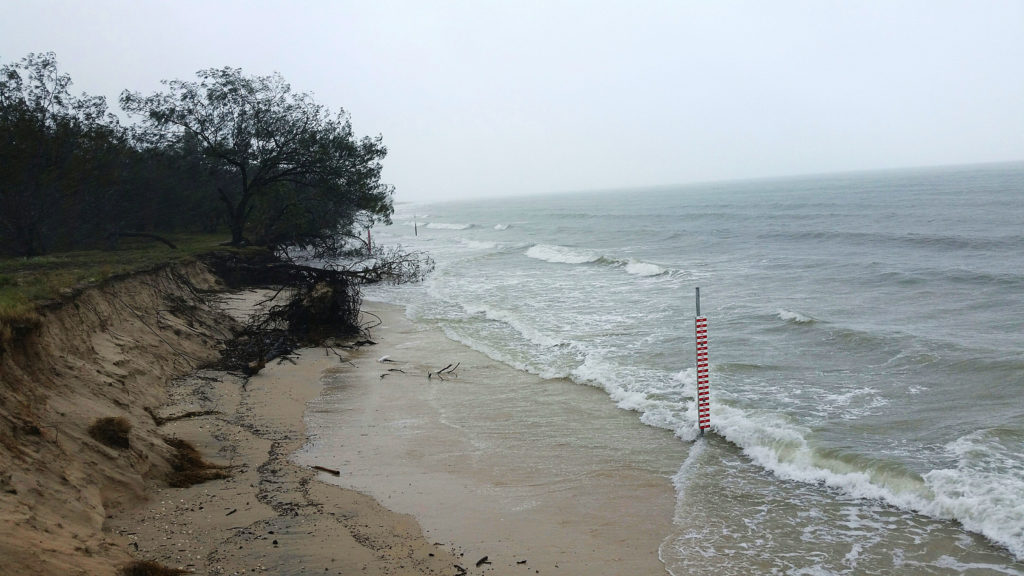
Abnormally high tides and dangerous surf conditions are expected along the southern Queensland coast over the next few days and into early next week.
Seas and swell are expected to increase well ahead of the approach of Oma with dangerous surf developing about the east coast of Fraser Island and Wide Bay coast north of Bargara later this afternoon and evening.
These conditions are then expected to extend south over the remaining southeastern Queensland coast and northern New South Wales coast during this evening and Friday. Beach erosion is likely to continue with the hazardous marine conditions.
Severe weather warnings for abnormally high tides and dangerous surf are current. A hazardous surf warning is also current.
Gale force winds are expected to develop along exposed coastal areas of southern Queensland during Friday well ahead of Oma.
Water levels on the high tide may exceed the highest tide of the year by around one metre on the morning high tides over the next few days.
The current forecast for Bundaberg shows 3-15mm of rain on Saturday, 4-30mm on Sunday and 6-35mm on Monday.
People should monitor weather forecasts and local media, and heed any advice from emergency services.
For advice about preparing for possible severe weather visit the Get Ready Queensland website.
For updates on emergency news, road closures and weather warnings visit the Bundaberg Regional Council Dashboard.
Current details of Tropical Cyclone Oma
- Intensity: category 2, sustained winds near the centre of 95kmh with wind gusts to 130kmh.
- Location: within 35km of 22.6 degrees south, 160.0 degrees east , 890km northeast of Brisbane and 820km east-northeast of Bundaberg.
- Movement: southwest at 11kmh.
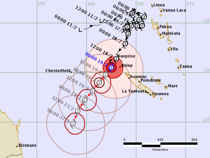
WEDNESDAY 6pm UPDATE: Tropical Cyclone Oma is expected to continue moving in a general southwesterly direction for the next few days while maintaining category 2 intensity, bringing it closer to the southeast Queensland coast on Friday.

No Tropical Cyclone Advice is current for this system.
At 5pm today the bureau issued a warning for abnormally high tides and dangerous surf for areas south of Seventeen Seventy to Moore Park Beach.
Potential high tides could also effect Burnett Heads, Bargara and Woodgate.
The bureau says water levels on the high tide may exceed the highest tide of the year by around one metre on the morning high tides on Thursday and Friday.
The weather bureau update at 4pm today says Oma's motion becomes slow moving and more uncertain over the weekend, possibly taking a more northwest track off the Queensland coast.
The hazardous surf warning and Flood Watch alert remain in place.
Details of Tropical Cyclone Oma at 4pm
- Intensity: category 2, sustained winds near the centre of 110kmh with wind gusts to 155kmh.
- Location: Within 35km of 21.6 degrees south, 160.9 degrees east, 1030km northeast of Brisbane.
- Movement: Southwest at 9kmh.
WEDNESDAY 3pm UPDATE: The weather bureau has issued initial Flood Watch advice for coastal catchments between Gladstone and the NSW Border and adjacent inland areas.
This includes Baffle Creek, Kolan River and Burnett River.
The bureau says river level rises above the minor flood level are possible across the Flood Watch area during the weekend and early next week.
There is a risk of moderate to major flooding, depending on the movement of Tropical Cyclone Oma.
The bureau expects Tropical Cyclone Oma to continue its track towards the southern Queensland coast in the coming days, which may produce heavy rainfall over the weekend and early next week.
The specific area and duration of this heavy rainfall depends on the track of Tropical Cyclone Oma.
The bureau commentary notes that catchments across southern Queensland remain quite dry after a delayed start to the wet season, however areas where intense rainfall is recorded will likely respond quickly.
Based on the current forecast track, minor flooding is possible in coastal catchments south of Bundaberg from early in the weekend.
Heavy rainfall may also lead to localised flooding.
A spokesman for Bundaberg Regional Council said the Flood Watch advice was not unexpected given the uncertain path of Tropical Cyclone Oma.
“People should monitor weather forecasts and local media, and heed any advice from emergency services,” the spokesman said.
For advice about preparing for possible severe weather visit the Get Ready Queensland website.
For updates on emergency news, road closures and weather warnings visit the Bundaberg Regional Council Dashboard.

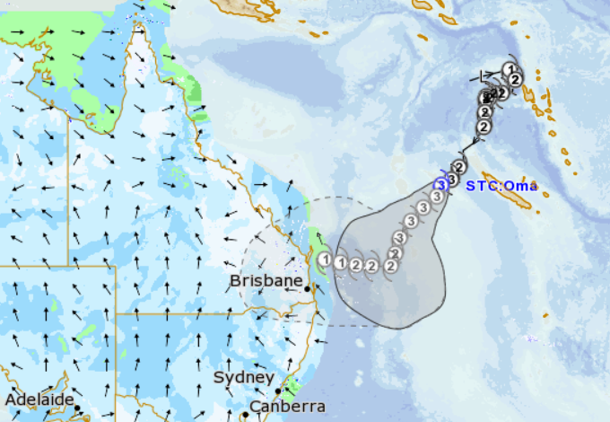
WEDNESDAY 11am UPDATE: Tropical Cyclone Oma is expected to move slowly southwest over the Coral Sea during the next few days.
Abnormally high tides, dangerous surf and strengthening winds are expected along the southern Queensland coast.
Tropical Cyclone Oma is expected to continue moving in a general southwesterly direction for the next few days while maintaining category 2 intensity, bringing it closer to the southeast Queensland coast on Friday and over the weekend.
At 10am Wednesday, the bureau's update was:
- Intensity: category 2, sustained winds near the centre of 110kmh with wind gusts to 155kmh.
- Location: Within 35km of 21.1 degrees south, 161.4 degrees east, 1110km northeast of Brisbane .
- Movement: southwest at 9kmh.
WEDNESDAY 7am UPDATE: The hazardous surf warning remains in place.
The weather bureau is now forecasting up to 60mm of rain for Bundaberg on each of Saturday and Sunday. The predicted range is 0-60mm depending on the movement of Tropical Cyclone Oma.
At 4am Wednesday, the bureau's update regarding Tropical Cyclone Oma was:
- Intensity: category 3, sustained winds near the centre of 130kmh with wind gusts to 185kmh.
- Location: Within 35km of 20.9 degrees south, 161.6 degrees east , 1140km northeast of Brisbane .
- Movement: southwest at 10 kilometres per hour.
- Severe Tropical Cyclone Oma is expected to continue moving in a general southwesterly direction for the next few days, bringing it closer to the southeast Queensland coast late in the week or over the weekend.
- Hazards: Abnormally high tides are expected along the southern Queensland coast in the next few days. Seas and swell are also expected to increase well ahead of the approach of Oma. A severe weather warning and hazardous surf warning are current.
A spokesman for Bundaberg Regional Council said the movement of Tropical Cyclone Oma and its potential impact remains uncertain.
“People should monitor weather forecasts and local media, and heed any advice from emergency services,” the spokesman said.
EARLIER (Tuesday): The weather bureau has issued a hazardous surf warning for the Queensland Coast from the NSW border to Gladstone as Cyclone Oma continues to remain active in the Pacific.
The bureau is also forecasting up to 50-60mm of rain for Bundaberg on Sunday and Monday.
Surf and swell conditions are expected to be hazardous for coastal activities such as rock fishing, boating and swimming from late Tuesday evening onwards.
Surf Life Saving Queensland advise that:
- People should consider staying out of the water and avoid walking near surf-exposed areas.
- Rock fishers should avoid coastal rock platforms exposed to the ocean and seek a safe location that is sheltered from the surf.
- Boaters planning to cross shallow water and ocean bars should consider changing or delaying their voyage.
- Boaters already on the water should carry the appropriate safety equipment and wear a lifejacket.
- Boaters should remember to log on with their local radio base and consider their safety management plan.
High tides over the next two days in tandem with rough surf whipped up by Cyclone Oma may impact erosion-prone beaches in the Bundaberg Region.
At 2pm Tuesday the bureau said the cyclone was likely to continue tracking slowly in a southwesterly direction towards the east coast of Queensland late this week and over the weekend, resulting in hazardous surf conditions and abnormally high tides developing about the southern Queensland and far northern New South Wales coasts from Wednesday.
“While some models have the tropical cyclone remaining offshore of southern Queensland, there is a possibility that the tropical cyclone may near or even cross the east coast late in the weekend,” the bureau reported.
“The position of the tropical cyclone will depend on the movement and development of an upper level trough during the coming days.”
The effects of a high tide of 3.61m in the region tomorrow at 9am is likely to be accompanied by large waves.
Beaches from 1770 south are expected to be impacted.
Bundaberg Regional Council’s Engineering Services manager Dwayne Honor said that while beaches at Woodgate and Moore Park are likely to experience some erosion, residents should remain alert and not alarmed.
“There is every likelihood that any sand eroded over the next couple of days as a result of increased wave action is likely to be replaced naturally within three to six months,” he said.