
UPDATE (6am MONDAY): Severe weather bypassed the Bundaberg Region overnight with rainfall totals much lower than forecast.
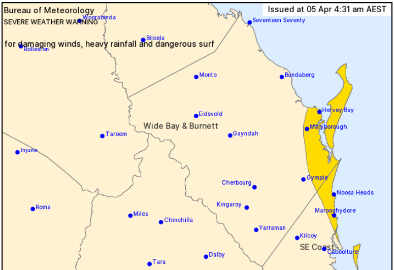
The warning area for severe weather on Monday now covers the Fraser Coast and Sunshine Coast.
Rainfall totals since 9am Sunday: Bargara 19mm, Cordalba 19, Moore Park Beach 18, Woodgate 18, Bundaberg 17, Branyan 17, Gregory River 16, Gin Gin 13, Bucca Weir 11, Paradise Dam 5.
The storage at Paradise Dam has risen slightly to 44.5 per cent of its currently reduced capacity at 75,875 megalitres.
The Bundaberg forecast for the rest of Monday is for showers and a maximum temperature of 27 degrees.
Weather situation: A subtropical low off the Capricornia Coast, combining with a strong upper level low, is expected to adopt a south to southeasterly track and move off the coast around Rainbow Beach or Noosa Heads later today. Overnight the low remained offshore keeping severe weather away from the coast, but the risk of severe impacts remains should the low move closer to the coast today.
HEAVY RAINFALL which may lead to FLASH FLOODING may develop over areas between Hervey Bay and the Sunshine Coast today. Six-hourly rainfall totals between 120 to 160mm are possible in areas.
INTENSE RAINFALL that may lead to DANGEROUS AND LIFE-THREATENING FLASH FLOODING and DAMAGING WIND GUSTS to around 90kmh are possible over communities east of about Maryborough and Noosa Heads. Isolated six-hourly rainfall totals up to 250mm are possible, particularly over Fraser Island.
EARLIER (5.10pm SUNDAY): The weather bureau has warned of possible intense rainfall and damaging wind gusts in the Bundaberg area tonight.
Weather situation: A subtropical low off the Capricornia Coast is forecast to combine with a strong upper level low and deepen while moving south towards Hervey Bay waters. It is then expected to adopt a south to southeasterly track early on Monday morning and move off the coast around Rainbow Beach or Noosa Heads during the day.
HEAVY RAINFALL which may lead to FLASH FLOODING is likely to develop over areas between Seventeen Seventy and the Sunshine Coast later tonight and through Monday. Six-hourly rainfall totals between 120 to 160 mm are likely in areas.
INTENSE RAINFALL that may lead to DANGEROUS AND LIFE-THREATENING FLASH FLOODING and DAMAGING WIND GUSTS to around 90 km/h are possible over communities east of about Bundaberg, Maryborough and Noosa Heads later tonight and through Monday. Isolated six-hourly rainfall totals up to 250 mm are possible, particularly over Fraser Island.
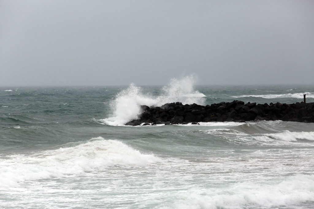
DANGEROUS SURF is likely to develop about the Fraser Coast tonight, extending south to the Sunshine Coast on Monday morning and Moreton Bay Islands later in the day.
A Flood Watch is current for coastal catchments south of St Lawrence, extending inland to the Darling Downs.
Locations which may be affected include Bundaberg, Fraser Island, Hervey Bay, Maryborough, Nambour, Rainbow Beach, Tiaro, Noosa Heads, Sunshine Coast, Moreton Island and Stradbroke Islands.
Queensland Fire and Emergency Services advises that people should:
- Move your car under cover or away from trees.
- Secure loose outdoor items.
- Seek shelter, preferably indoors and never under trees.
- Beware of fallen trees and powerlines.
- Never drive, walk or ride through flood waters. If it's flooded, forget it.
- Keep clear of creeks and storm drains.
- Surf Life Saving Australia recommends that you stay out of the water and stay well away from surf-exposed areas.
- Check your property regularly for erosion or inundation by sea water, and if necessary raise goods and electrical items.
- For emergency assistance contact the SES on 132 500.
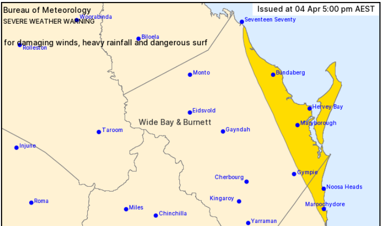
EARLIER (7.30am SUNDAY): A severe weather warning for heavy rainfall has been issued for people in parts of the Wide Bay and Burnett and Southeast Coast forecast districts.
The weather bureau says heavy rainfall may lead to flash flooding over areas between Seventeen Seventy, Gympie and Caloundra on Sunday night and into Monday.
Six-hourly rainfall totals between 120 to 160mm are likely in areas with locally intense falls of 200 to 250mm possible over coastal communities and Fraser Island.
A Flood Watch is current for coastal catchments between St Lawrence and the Queensland/New South Wales border, extending inland to the Darling Downs.
Locations which may be affected include Fraser Island, Seventeen Seventy, Maroochydore, Gympie, Bundaberg, Noosa Heads, Hervey Bay, Maryborough, Nambour, Rainbow Beach and Tiaro.
Queensland Fire and Emergency Services advises that people should:
- Never drive, walk or ride through flood waters. If it's flooded, forget it.
- Keep clear of creeks and storm drains.
- For emergency assistance contact the SES on 132 500.
To stay up to date with weather warnings and alerts, visit the Bundaberg Region Disaster Dashboard.
EARLIER (6pm SATURDAY): The weather bureau has issued a Flood Watch alert for Queensland catchments including Baffle Creek, Kolan River, Burnett River and Burrum River.
The Bundaberg forecast is for 50-100mm of rain on Sunday and 25-60mm on Monday.
The bureau says a deepening trough along the Queensland coast is likely to bring heavy rainfall to the Flood Watch area from Sunday and continue into Monday.
The heaviest falls are likely to occur north of Fraser Island initially, extending southwards to the Queensland-New South Wales border by Monday.
Catchments to the north of the Sunshine Coast are generally dry and will be slower in responding to heavy rainfall. Catchments in southeast Queensland however are wet from recent rainfall and will likely to respond quickly.
Minor to moderate flooding is possible in the Flood Watch area from late Sunday into Monday. Isolated major flooding is possible.
Localised flooding and disruption to some transport routes are likely.
Bundaberg Region Mayor Jack Dempsey said rain will be welcome, but people should be wary of localised flash flooding if the forecast proves correct.
“Stay up to date with warnings and information on the Bundaberg Region Disaster Dashboard at http://disaster.bundaberg.qld.gov.au/,” he said.
Severe weather warning (5.01pm Saturday)
HEAVY RAINFALL which may lead to FLASH FLOODING may develop over areas between Seventeen Seventy, Gympie and Caloundra on Sunday night and into Monday. Six-hourly rainfall totals between 120 to 160 mm are likely in areas with locally intense falls up to 200 mm possible over coastal communities and Fraser Island.
A Flood Watch is current for coastal catchments between St Lawrence and the Queensland/New South Wales border, extending inland to the Darling Downs.
Locations which may be affected include Fraser Island, Seventeen Seventy, Maroochydore, Gympie, Bundaberg, Noosa Heads, Hervey Bay, Maryborough, Nambour, Rainbow Beach and Tiaro.
Queensland Fire and Emergency Services advises that people should:
- Never drive, walk or ride through flood waters. If it's flooded, forget it.
- Keep clear of creeks and storm drains.
- For emergency assistance contact the SES on 132 500.

- Other news: Easter worship goes ahead, including beach service
- TEN/1371 – Supply of Electrical Switchboards
- Way out West tour lands at Hinkler Hall of Aviation


