
The Bundaberg East Levee project is a step closer to being delivered, with project commencement approvals in place and engineering consultants being sought to finalise the levee’s design.
The $174.7 million project, jointly funded by the Australian and Queensland Governments, is aimed at providing better protection for parts of Bundaberg East, Bundaberg South and the CBD.
The project will not only help safeguard homes, businesses and the local economy from the devastation of major flooding but will also support more than 100 jobs and local business opportunities during its construction.
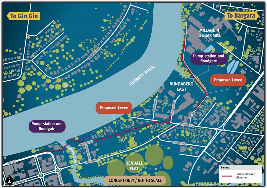
A 1.7 km concrete levee parallel to the southern bank of the Burnett River will mitigate damage from a Burnett River flood without increasing flooding in other areas of Bundaberg.
Federal Minister for Emergency Management, Murray Watt said he was pleased the major project was moving forward with a clear object to protect homes and businesses.
“We know disruptions caused by natural hazards can have devastating economic effects and takes a toll on people lives and wellbeing, which is why we are making a real difference through this project,” he said.
“I commend the Queensland Government’s progress on this levee, and while there is still a long way to go, we look forward to collaborating even further to increase Bundy’s flood resilience.”
Bundaberg Regional Council Mayor Jack Dempsey said it was extremely important to Council that any levee or other works not have a negative impact on other parts of the city.
“I’m pleased to say that scientific analysis and modelling so far has shown that the proposed levee can do its job while not making things worse in other areas of the city,” Mayor Dempsey said.
“I’m confident that as further analysis and refinement of the design takes place that we will end up with the best possible result all round.
“Construction of the Bundaberg East levee is one of the four projects listed under the Bundaberg Action Plan and it is gratifying to see progress being made.”
Engineering and community consultation
In the coming months, the project’s reference design – originally developed with community consultation in 2018 – will be further refined by an engineering consultant in conjunction with the Bundaberg community and project stakeholders.
Member for Bundaberg Tom Smith said the levee would serve not only residents, but sporting clubs, school communities, charity organisations, and local business as well.
“Where we can stop flooding, we should stop flooding and that is exactly why this project is so important to Bundaberg,” he said.
“I have already spoken with a range of locals wishing to share their community contributions, and this will form a key part of the consultation and procurement phase.”
Minister for Public Works Mick de Brenni said the project was vital for ensuring Bundaberg was as safe from flooding as possible.
“It’s important that the people of Bundaberg have a voice in the project delivery process, which is why we invite community members to visit the project website and register for updates and invitations to 2024 community events,” Minister de Brenni said.
“We expect construction to begin by early 2025 and the final design will determine how long construction takes.”
The reference design includes a concrete levee in two main sections, as well as floodgates, flood doors and pump stations across Saltwater Creek and an unnamed creek known locally as ‘Distillery Creek’.
The levee was the most beneficial of four options identified under the 10-year Bundaberg Action Plan as able to help reduce the risk of flood devastation such as the all-time record flooding caused by ex-Tropical Cyclone Oswald in 2013 and the significant rainfall and flooding early last year.
Bundaberg Action Plan
The Bundaberg Action Plan recognises and responds to changing needs and flood risk conditions following its launch in 2017.
The plan is based on options from a Flood Mitigation Options Assessment Report developed by an independent consultant based on community feedback and technical studies.
After further community consultation in 2018, four options were chosen by the community and experts to future flood-proof affected residents and businesses.
- Bundaberg North Evacuation Route Improvements: upgrading connection between Bundaberg North and the CBD during flood events.
- Bundaberg Flood Levee: mitigating damage from a Burnett River flood within Bundaberg East, Bundaberg South and the CBD without increasing flood issues in other areas.
- Upper Flood Plain Evacuation Improvements: reducing the isolation time of Goodnight Scrub, Morganville, Pine Creek, Givelda and Electra.
- Floodway House Purchase Scheme: voluntarily purchase or relocation of homes through a land-swap of selected residential blocks in Bundaberg North deemed to be in a floodway with high depths and velocities.
The action plan’s projects remain subject to ongoing consideration.
Bundaberg community members are invited to visit the Bundaberg East Levee project website and subscribe to the email list to receive project updates and invitations to community events.


When will our individual councillors take a stand and do a survey of their constituents within their divisions. They will get a shock when they see just how many people do not want the levee
Why is this comment of mine not shown?
If I need to I will go public with this issue
When will our individual councillors take a stand and do a survey of their constituents within their divisions. They will get a shock when they see just how many people do not want the levee
this will be interesting, big pumps, bit like ballast pumps, requiring lots of power. solar powered are they to be? no sun for several days. Hydrogen powered? England saw a failure of one pump during a severe storm. it was a real catastrophe. the people we visited took us into this area. i think they also had reliable nuclear power. no power, no pump, murphy’s law will always prevail.
Having purchased in East Bundaberg after being effected by the floods in the Northern Rivers twice in one month.
The highway built created a levee wall, Lismore also has a levee wall.
These levees created and allowed further damage to occur to Lismore, Woodburn, Coraki, Byron Bay, Ballina, Lennox Head etc because it pushed and trapped the water in these locations.
A levee wall WILL increase the chance of major flood events as already seen in Lismore, occurring to the entirety of Bundaberg East and Surrounding suburbs.
Please learn from Lismore/Northern Rivers about the damages caused/lives lost from a levee wall that caused a waterfall effect.
But we refuse to learn from the mistakes of others. Engineers were ADAMENT the dam was safe. Spent all OUR money building it then spent EVEN MORE OF OUR money “resizing” it to make it safe.
Fix the drain up , ie. the river .Much better spend of taxpayers money
the burnett river was once a river. who tinkered with this and altered the whole system. the mismanagement of the river started around 1882 according to an archived maritime chart. instead of now having broad sections, we have rock lined ditches. read some old votes and proceedings to see what was done. the last major catastrophe was pumping sand onto a wet land for the value of one pepper corn.